 Finally finding time to tag, label, metalabel, geo-reference and all that the pictures I took over Easter. Making that task a whole lot easier is a new little application I found called [Geotagger]
http://craig.stanton.net.nz/software/Geotagger.html. It does one thing -- adding latitude and longitude to pictures -- really well. I’ve other applications that make it easy to add the information from a GPS device. But if you don’t have a track it can be much harder to place the pictures on a map. Geotagger uses Google Earth to do the job. The coordinates at the centre of the Google Earth map are written to any JPG image you drag onto Geotagger, and that’s it. Once they're on Flickr, they appear on my Flickr map automagically. Maybe I should also subscribe to Panoramio,1 but do I really want to clutter Google Earth with my snaps? I think not.
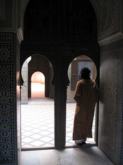
Eventually I’ll get round to organizing the Morocco photos into sets, but not for a while.
-
2022-05-07: Dead now, obvs, like so many good Google things. ↩
Webmentions
Webmentions
Webmentions allow conversations across the web, based on a web standard. They are a powerful building block for the decentralized social web.
If you write something on your own site that links to this post, you can send me a Webmention by putting your post's URL in here:
Comments